 |
|||||||||||||||||||||||||||||||||
|
Winter Storms
The Basics
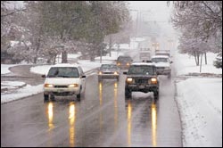
Winter storms are among nature's most impressive weather spectacles. Their combination of heavy snow, freezing rain, and high winds can totally disrupt modern civilization: closing down airports and roads, creating power outages, and downing telephone lines. Winter storms remind us how vulnerable we are to nature's awesome power. A blizzard is defined by winds blowing at 35 miles per hour or higher. One of the reasons why blizzards are so dangerous is the reduced visibility due to snow flying everywhere from the fast wind. These storms derive their energy from the clash of two air masses of substantially different temperatures and moisture levels. An air mass is a large region above the Earth, usually about 1,000-5,000 km in diameter, with a fairly uniform temperature and moisture level. In North America, winter storms usually form when an air mass of cold, dry, Canadian air moves south and interacts with a warm, moist air mass moving north from the Gulf of Mexico. The point where these two air masses meet is called a front. If cold air advances and pushes away the warm air, it forms a cold front. When warm air advances, it rides up over the denser, cold air mass to form a warm front. If neither air mass advances, it forms a stationary front. A winter storm is composed of three factors: cold air, moisture, and
lift. Winter storms usually form along a stationary front. An area of lower pressure develops along the front as the atmosphere tries to even out the pressure difference. This creates wind, which blows from high pressure towards low pressure, in an attempt to move enough air to even out the pressure difference. As the air moves toward the low-pressure area, it has nowhere to go but up into the colder regions of the atmosphere. This causes water vapor in the air to condense. To the north of the storm, where temperatures are colder, this condensed water falls as snow. To the south, if the temperatures are warm enough, it can fall as heavy rain in thunderstorms. Learn more about winter storms in-depth.
|
||||||||||||||||||||||||||||||||