 |
Inangahua
Junction and Earthquake Flat |
 |
|
 The earth is not a ball of solid rock, but a changing, restless planet. When tectonic plates move suddenly, the ground shakes and convulses — what we call an earthquake. Did you know that every two weeks a major earthquake occurs somewhere in the world? Most of these occur under the sea, but sometimes they happen where people live.
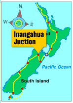
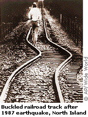
New Zealand is positioned where two tectonic plates meet and push against each other. This is causing the formation of large mountains in the south and cracks in the earth's crust called faults in the north — and is the major force behind the many earthquakes that occur in New Zealand. In the 1930s, the town of Napier, located in the eastern part of New Zealand's North Island, was totally destroyed by an earthquake. More recently, Inangahua Junction, located in the South Island of New Zealand, was at the epicenter of an earthquake that measured 7 on the Richter scale. Colin's trek took him first across Earthquake Flat — an area just south of Rotorua where there are 1,000 earthquakes a year. (That averages to about three each day!) In this area, he talked to seismologists, who study earth tremors and try to predict when major quakes will happen next. Then he visited Inangahua Junction and observed the effects of the recent earthquake on the land and people. Want to learn more about earthquakes? Check out these Web sites to find out where earthquakes are happening around the world, see an animation of an earthquake in action, and more. |
|||
|
|||