Tornadoes
In-Depth
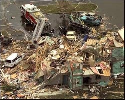 |
| Tornados can cause severe damage like this demolished
apartment house in Florida in 1998. (Photo: © J. Pat Carter/AP
Wide World) |
Keep reading to find out…
Where do tornadoes occur?
How are they measured?
How does the warning system work?
Where do they occur?
The U.S. has by far the most tornadoes in the world.
It averages 1,000 tornadoes a year! Tornadoes also occur in other parts
of the world, most notably in Australia.
The geography of the central U.S. is uniquely suited to bring together
all the ingredients for tornado formation. With the Rocky Mountains
to the west, the Gulf of Mexico to the south, and a terrain that slopes
downward from west to east, this area has become known as "Tornado
Alley," averaging more than 500 tornadoes annually.
During the spring and summer months, southerly winds originating from
the Gulf of Mexico prevail across the plains, providing the warm, humid
air needed to fuel severe thunderstorm development. Hot, dry air forms
over the higher elevations to the west, and becomes the cap as it spreads
eastward over the moist, Gulf air. Where the dry air and the Gulf air
meet near the ground, a boundary known as a dry
line forms to the west of Oklahoma. A storm system moving out of the
southern Rockies may push the dry line eastward, with severe thunderstorms
and tornadoes forming along the dry line or in the moist air just ahead
of it.
Peak months of tornado activity in the U.S. are April, May, and June.
However, tornadoes have occurred in every month and at all times of
the day or night. A typical time of occurrence is on an unseasonably
warm and humid spring day between 3 p.m. and 9 p.m.
When a storm system high in the atmosphere moves east and begins to lift
the layers, it begins to build severe thunderstorms that spawn tornadoes.
As it lifts it removes the cap, setting the stage for explosive thunderstorms
to develop as strong updrafts form. If the rising air encounters wind
shear, it may cause the updraft to begin rotating, and a tornado is born.
The states at the highest risk of getting a tornado include
Arkansas, Iowa, Kansas, Louisiana, Minnesota, Nebraska, North Dakota, Ohio, Oklahoma,
South Dakota, and Texas. Collectively, these states are called "Tornado Alley”.
How are they measured?
Dr. T. Theodore Fujita ("Dr. Tornado") was a pioneer in the
study of tornadoes and severe thunderstorm phenomena. In 1971, he created
the Fujita Tornado Damage Scale to estimate tornado strength based
on damage surveys. Since it's extremely difficult to measure tornado winds
directly, this is the best way to classify them.
The scale of a tornado is measured from F0 to F5,
or lowest danger to highest danger. An F0 tornado reaches winds from 40–72
miles per hour, while an F5 tornado can tear through land at 261–318 mph.
The scale goes up to F5 — or up to 318 mph. It's
possible that a tornado could generate winds above the scale, but it has
never been recorded. On May 3, 1999, an Oklahoma University Doppler radar
remotely sensed tornado wind speeds above ground of 318 mph at Bridge
Creek, Oklahoma — the highest winds ever found near Earth's surface,
and right at the threshold of being F6 winds.
Fujita Tornado Damage Scale — Developed by "Dr. Tornado",
T. Theodore Fujita of the University of Chicago
The chart below includes links to photographs outside of Scholastic.com
We checked each of these links to make sure it was appropriate. But we
don't monitor or control these sites and they can change. They also may
have links to other sites that we haven't reviewed. Be sure to get permission
from your parents or teacher before leaving this site, and remember to
read the Privacy Policy and Terms of Use of any site you visit.
| Scale |
Wind Estimate (mph) |
Typical Damage |
| F0 |
< 73 |
Light
damage.
Some damage to chimneys and TV antennas; breaks twigs off trees; pushes
over shallow-rooted trees. |
| F1 |
73-112 |
Moderate
damage.
Peels surface off roofs; windows broken; light trailer houses pushed
or overturned; some trees uprooted or snapped; moving automobiles
pushed off the road. The beginning of hurricane wind speed is 74 mph.
|
| F2 |
113-157 |
Considerable
damage.
Roofs torn off frame houses, leaving strong upright walls; weak buildings
in rural areas demolished; trailer houses destroyed; large trees snapped
or uprooted; railroad boxcars pushed over; light-object missiles generated;
cars blown off highway. |
| F3 |
158-206 |
Severe
damage.
Roofs and some walls torn off frame houses; some rural buildings completely
demolished; trains overturned; steel-framed hangar-warehouse-type
structures torn; cars lifted off the ground; most trees in a forest
uprooted, snapped, or leveled. |
| F4 |
207-260 |
Devastating
damage.
Whole frame houses leveled, leaving piles of debris; steel structures
badly damaged; trees debarked by small flying debris; cars and trains
thrown some distances or rolled considerable distances; large missiles
generated. |
| F5 |
260-318 |
Incredible
damage.
Whole frame houses tossed off foundations; steel-reinforced concrete
structures badly damaged; automobile-sized missiles generated; trees
debarked; incredible phenomena can occur. |
| F6-F12 |
319 to sonic |
Inconceivable damage.
Should a tornado with the maximum wind speed in excess of F5 occur,
the extent and types of damage may not be conceived. A number of missiles
such as iceboxes, water heaters, storage tanks, automobiles, etc.
will create serious secondary damage on structures. |
How does the warning system work?
There are five basic steps in the National
Weather Service warning system. Every part of the system has to work
for the greatest number of people to get the warning in time.
Step 1. The Tornado Watch
The forecasters at the Storm Prediction
Center in Kansas City, Missouri, use satellite pictures, radar reports,
numerous weather charts, and other tools to predict where severe thunderstorms
and tornadoes are likely to occur. When they determine it's likely that
a severe storm may occur, they issue a tornado or severe thunderstorm
watch. Watches may be issued hours before a severe storm hits an area.
Step 2. Spotters
Once a tornado watch has been declared, the spotters get busy. Spotters
— the National Weather Service's eyes in the field — report
critical weather information as it is happens. If a Spotter sees a tornado,
she immediately transmits this information to the National Weather Service
through the information network known as Skywarn.
This changes the tornado status from a watch to a warning. Most tornadoes
are detected by the use of Doppler radar, but the spotter system still
accounts for reporting many tornadoes. In order to become a Spotter, you
need to pass a Skywarn training program. Find out more about Storm
Spotters.
Step 3. Civil Defense and the State Police
Once a tornado watch is issued, the National Weather Service alerts the
state and local civil defense organizations and the state police. This
allows authorities to prepare for a possible emergency.
Step 4. Informing the Public
If it seems likely that a tornado or other weather emergency will hit
an area, the National Weather Service has a direct line to local media
offices so that they can relay the information to the public as quickly
as possible.
Step 5. The Users
Users include everyone within the severe thunderstorm or tornado warning
area. The best way to save lives is to reach the greatest number of people
possible to tell them that they need to prepare. Even if every other step
in the warning system works, it does little good unless the users know
what to do, and act. The best way to receive timely tornado warning advisories
is through use of a NOAA Weather Radio with a warning alarm and battery
backup.
|